 The equation E=mc² is linked in many people's minds to nuclear energy.
That's the impression I got from how I saw it taught in school:
E=mc² was presented in the context of calculating the energy
released by fission or fusion reactions. The huge c² factor
helps explain how so much energy can come from a small amount of fuel.
But E=mc² applies to any and all energy. Energy has mass. When you wind a clock, it gets a little bit heavier.
People may look at you funny when you tell them this. It's counterintuitive. We're used to thinking of mass as a property of stuff and energy doesn't seem like stuff.
Even if someone grudgingly accepts that a clock gets heavier when you wind it, they may take solace in the fact that it's only a tiny bit heavier. Most of the mass comes from the stuff the clock is made of. Mass from the energy stored by winding up the mainspring is less than a drop in a bucket.
But stuff turns out to be mostly energy. The lion's share of mass in an atom is in the nucleus, protons and neutrons, which are in turn made of quarks. The quarks alone don't have much mass; about 99% of a proton's or neutron's mass comes from binding energy. Sometimes you don't need to see coördinates from a GPS receiver, you just let your phone or other device show your location on a map. But if you're looking to calculate how far apart two places are or to find a spot a mile east of where you are, you may want to use numbers. Latitude and longitude are not great for such purposes because it's a pain to convert them into distances. Better are UTM (Universal Transverse Mercator) coördinates, which are positive decimal (x,y) values in meters ("easting" and "northing"). They're not exactly equal to meters on the ground (because of discrepancies inherent in map projection) but they're pretty close. UTM divides the earth into sixty zones and uses a different projection for each zone. If the area you're working in doesn't straddle a zone boundary, UTM coördinates are easily subtracted to get displacements in meters.
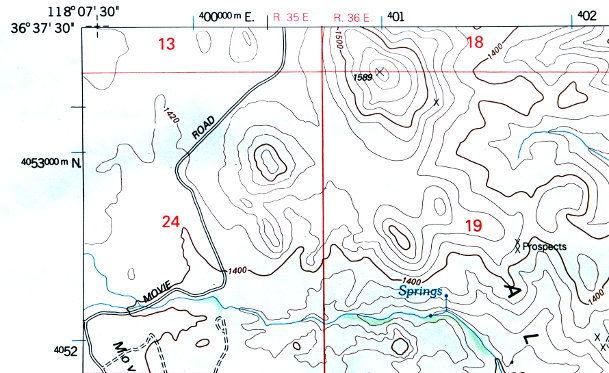
UTM coördinates can have a lot of digits and sometimes they are given in truncated form for simplicity. In this map excerpt, 400000 and 4053000 are in meters; 401, 402, and 4052 are in kilometers. By convention, UTM coördinates are written in small and large digits—the tens and units km digits being large—so that even when they are truncated, you know what units to interpret them as.
 To get a feel for how UTM works (and how it
compares to latitude and longitude), there's a nice tool at
mappingsupport.com
that overlays maps with UTM grid lines.
|
UTM's grid lines curve with respect to due east/west and north/south
(in any map projection, something has to give).
Topo maps often have a key to show you roughly how much UTM's
vertical grid lines diverge from true north in the area mapped
(along with how far magnetic north is off).
The angles on the map legend shown here are given in degrees+minutes
of arc and also in mils (thousandths of radians).
In this example,
the UTM vertical grid lines diverge from true north by 11 mils.
Expressing the divergence in mils makes for convenient adjustments:
to move one km true north from a location in this area,
add 1000 meters to UTM northing and 11 meters to UTM easting.
(An approximation, but close enough for most purposes.
For small angles,
cos(θ) ≈ 1 and
sin(θ) ≈ θ.)
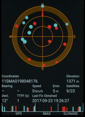
I wish I could stop here because UTM is so sensible, but sometimes one encounters coördinates in MGRS (military grid reference system), a kludgey and cryptic way to express what UTM says directly. |
 The screenshot to the right shows a
satellite
navigation app displaying MGRS coördinates
11SMA0198048176 that correspond to
UTM Zone 11,
401980E,
4048176N.
MGRS coördinates incorporate digits from the equivalent
UTM coördinates, but the rules for encoding/decoding the
prefix letters are dopey.
The S in 11SMA
is a subdivision based on lines of latitude,
whereas the M and A are further subdivisions
based on UTM grid lines. If a hodgepodge of incongrous methods
of subdivision sounds like a recipe for confusion, that's because
it is.
|
 If the pic had a round table instead of a desk,
it would look like a setup for a Colt 45 commercial
(the brand ran some
truly bizarre
commercials on US television in the 1960s).
Saturn has two little moons that are roughly in the same orbit,
except one is a little closer to Saturn so it makes a revolution in
slightly less time—but when it catches up to the slower moon and
passes it, the two moons' mutual gravitational attraction transfers
some energy between them. The moons continually switch positions:
one is closer to Saturn for a while,
then the other, ... .
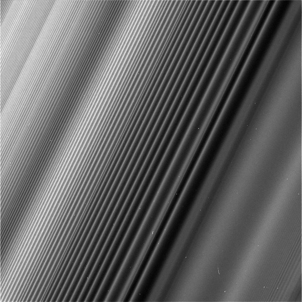
The gravitational field of two moons doing this kind of dance puts spiral lumps into an area of Saturn's ring:
 Some music I liked when I was a kid doesn't impress me much anymore,
and then there's some that I appreciate all the more as time goes on.
Steely Dan is in the latter category—their music has a lot
going on under the surface.
I like the early Steely Dan records the best. The later ones sold better and got awards.
I am saddened by Walter Becker's passing today but encouraged by Donald Fagen's tribute in which he affirms his intent to keep playing Steely Dan's music.
I like that Walter Becker's 1994 solo record has 12 tracks despite being named 11 Tracks of Whack and that it includes the song Lucky Henry which I think is an absolute gem.